


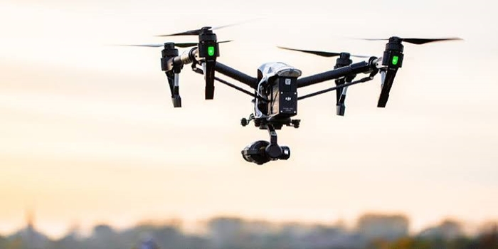
In this article, we discussed the drones, what drones are used for? The importance of drone’s inspection, the challenges, drones and the future of Nigeria oil and gas.
Definition
Drones are unmanned flying devices controlled remotely or programmed to operate automatically for tasks such as inspection, surveillance, and data collection. They are controlled remotely by a pilot or can be programmed to fly automatically using computers, GPS and sensors. In the oil and gas industry, drones are used to inspect pipelines, offshore platforms, storage tanks, refineries and other infrastructure. They can take high-resolution photographs, record videos, detect certain gas leaks and identify signs of damage or corrosion.
In oil and gas operations, they can be equipped with different payloads depending on the inspection task.
These can include:
High-resolution optical cameras
Thermal imaging cameras
Infrared sensors
Optical gas-imaging cameras
LiDAR systems
Multispectral cameras
Zoom cameras
Other specialized inspection sensors
The drone itself is therefore only part of the technology.
The real value comes from combining the aircraft, sensors, software and data analysis to produce useful information for engineers and maintenance teams.
For example, a drone flying around an offshore platform can capture detailed images of structural components, while thermal cameras can identify abnormal temperature patterns. A gas-imaging sensor may help identify leaks that cannot be seen by the human eye.
The information can then be reviewed by trained personnel and incorporated into maintenance and asset-management systems.
Why Drone Inspections Are Becoming Important
The petroleum industry contains many assets that are difficult to inspect.
Consider an offshore platform.
A conventional inspection may require personnel, safety equipment, scaffolding, access systems, boats or helicopters and carefully planned shutdown or work-at-height activities.
A drone can potentially inspect portions of the structure without requiring an inspector to physically reach every location.
The same principle applies to:
Flare stacks
Storage tanks
Pipelines
Bridges
Chimneys
Transmission lines
Offshore structures
Wellhead areas
Refineries
Processing plants
Remote production facilities
This does not mean drones eliminate the need for human inspectors. Rather, they can make inspection programmed faster, safer and more data-rich when appropriately deployed.
- Improving Worker Safety
One of the strongest arguments for drone inspections is safety.
Oil and gas facilities can contain hazardous environments involving:
Hydrocarbons
High temperatures
High pressures
Toxic gases
Moving machinery
Confined spaces
Offshore conditions
Heights
Corrosive substances
Putting fewer people directly into these environments can reduce exposure to some inspection-related hazards.
For example, inspecting the exterior of a tall flare stack traditionally may require workers to climb or use specialized access equipment.
A drone can fly around the structure and capture high-resolution imagery while the inspection team remains at a safer location.
- Inspecting Difficult-to-Reach Locations
Some oil and gas infrastructure is simply difficult to access.
An offshore platform may contain structural components located high above the sea.
A refinery may have tall stacks, tanks and complex pipework.
A pipeline may extend for hundreds of kilometres through remote terrain.
Manually inspecting every component can require considerable logistical planning.
Drones provide another option.
They can fly over, around or alongside infrastructure and capture images from multiple angles.
This can be particularly useful for preliminary inspections, routine monitoring and identifying areas that require closer examination.
- Pipeline Monitoring
Pipeline infrastructure is particularly suitable for drone-based monitoring.
Nigeria has an extensive network of oil and gas pipelines, and monitoring these assets is important for safety, environmental protection and production security.
NUPRC’s mandate includes monitoring pipelines carrying crude oil, natural gas and petroleum products.
Drones can help operators monitor pipeline corridors for visible indicators such as:
Encroachment
Construction activity
Vegetation changes
Exposed pipelines
Visible leaks
Damaged infrastructure
Erosion
Flooding
Unauthorized activity
Thermal or other specialized sensors may provide additional information depending on the application and operating environment.
- Detecting Oil and Gas Leaks
Leak detection is one of the most important applications of drone technology.
A conventional visual camera cannot necessarily detect every gas leak.
However, specialized optical gas-imaging cameras can help identify certain hydrocarbon emissions.
The United States Environmental Protection Agency recognizes drone-based optical gas-imaging cameras as a technology that can be used for specified oil and gas monitoring requirements when applicable conditions are met and properly trained personnel conduct the surveys.
- Monitoring Gas Emissions
Drones can also contribute to emissions monitoring
Oil and gas facilities can release methane and other gases through equipment leaks, vents and other sources.
NUPRC’s current regulatory framework includes requirements and guidance relating to methane and greenhouse-gas emissions reporting and measurement
Drone-mounted sensors can potentially survey areas that would otherwise be difficult to monitor efficiently from the ground.
For example, a drone can fly around a facility and collect data from multiple points.
When combined with other measurement technologies, this can help operators develop a more detailed understanding of emissions.
The broader benefit is that better measurement can support better management.
What cannot be measured accurately is difficult to manage effectively.
6.Creating Digital Records of Facilities
3D models
Digital maps
Orthomosaic images
Asset visualisations
Inspection databasesThis becomes particularly useful for large or remote facilities.
Challenges of Using Drones
Despite their benefits, drones have limitations.
Weather
Strong wind, heavy rain and poor visibility can affect drone operations.
This can be particularly important in Nigeria’s coastal and offshore environments.
Battery life
Many small drones have limited flight time.
Long-distance pipeline inspections may therefore require multiple flights or specialised systems.
Regulations
Drone operations must comply with applicable aviation, safety, facility and privacy requirements.
Cybersecurity
Connected drones and data systems can introduce cybersecurity considerations.
Data volume
A drone can generate enormous quantities of imagery, creating challenges around storage, processing and analysis.
Skilled personnel
Operators need trained pilots, engineers, inspectors and data specialists.
Sensor limitations
No single sensor can detect every type of defect.
Human verification
Important findings may still require physical inspection or specialist testing.
These limitations mean drone technology should be incorporated into a broader inspection strategy.
Conclusion
Drones are making oil and gas inspections safer, faster, and more efficient. They reduce personnel exposure to hazardous areas while providing high-quality data for detecting leaks, corrosion, and structural defects. As technology advances, drones will continue to improve asset integrity, maintenance, and overall operational safety.
READ: Using Drones for Industrial Inspections